
The supplementary information provided in this QR-code accessed script takes the form of a series of questions that you may have about the first main section of the exhibition.
- Why is the exhibition titled ‘Offa’s Dyke – A Window on Early Medieval Britain’?
The main reason is that it conveys, hopefully in a straightforward way, the idea that we can look at Offa’s (and Wat’s) Dyke not simply as linear earthworks, but rather as lenses through which we can glimpse the lived reality of a distant Early Medieval past in Britain. (The Early Medieval period was the timespan between the end of Roman Britain, 400-450AD, through to the Norman Conquest of Britain: conventionally in 1066 but parts of Wales effectively remained independent right through to the Tudor period).
As such, the Dykes are both symptomatic and emblematic of the struggle for cultural and political definition and dominion across Britain, especially in the half-century from approximately 780 to 830AD.
This was not just a contest between ‘Saxon’ and Welsh, but also between the spheres of influence (for example) of the nascent Welsh kingdom of Powys versus that of early Gwynedd; emergent Brycheiniog against established early Gwent. Also, the Kingdom of Mercia was asserting its dominance over the Anglo-Saxon kingdoms of East Anglia, Lindsey, Kent, Wessex, and Northumbria. And into that mix later came Irish, Vikings and Danes, at times drawing together into alliance against them both English and Welsh kingdoms.
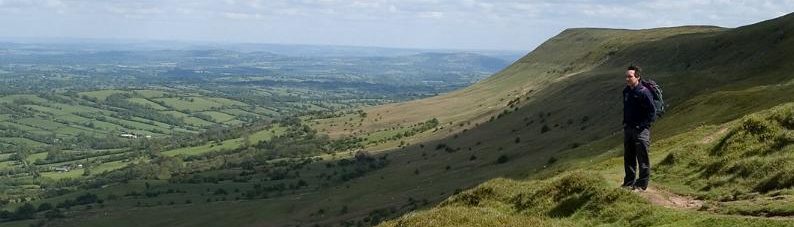
As an aside, we might also suggest that you look out of the picture windows all along the north side of the main hall of the Centre here. Looking across the park and up to the horizon you can see where Offa’s Dyke crosses the river Teme and can just make out where it climbs the hillsides to the north of the river, continuing northwards at this point over high hills towards the next major river-valley crossing, that of the Clun.
- Why were the English taking land from the Welsh?
The simplest answer to this question is, ‘Because they could.’ The Mercians particularly wanted to occupy broad undulating cornlands and river-valley pasture lands: because their farming economy was substantially based upon dairying and related industries. But it was a little more complicated than that. For example, the Mercians were also throughout the seventh and eighth centuries (and beyond) engaged in power-struggles with other Anglo-Saxon kingdoms and peoples and had expanding populations that they needed to find land for.
In contrast, the Cymru had suffered huge losses in population due to the pandemics of the fifth and sixth centuries and were themselves involved in internecine strife. To survive (and in order for one or another British/Welsh kingdom to hold power over its British neighbours), they formed alliances with one or other of the incoming Anglo-Saxon powers. But this led in turn to further incursions of the English and the loss of more lands to their settlers.
- What IS a Dyke, or ‘linear earthwork’?
We shall be describing this in later parts of the exhibition, but for now we can describe it most simply as a continuous bank with a ditch running alongside it. Such dykes were first built in Britain around three and a half thousand years ago: and amazingly, there are still traces of them to be seen in the landscape today. Some such ‘mini-dykes’ on the Long Mynd near Craven Arms in Shropshire have been dated to the Middle Bronze Age (c. 1200BC), for instance.
Dykes were also subsequently built by the sub-Roman authorities: in Dorset, for example, where the Bokerley Dyke deliberately cut across a Roman Road to inhibit unhindered movement along it.
There were several other Early Medieval dykes in the Welsh borderlands built before Offa’s and Wat’s Dykes. These were either built to resist English settlement or were built by the English to annexe land seized from the Britons/Cymru/Welsh people who formerly possessed it. (This did not always mean that the indigenous people were removed from the land, but they mostly lost control over it. Some Welsh communities survived in full title – for instance one between Leominster and Hereford – with their Welsh lords living some distance away in Wales through at least to the thirteenth century).
Such dykes often therefore cut across entire river-valleys. An example of such a dyke probably dating to around 650-700AD is the Rowe Ditch near Pembridge in north-west Herefordshire.
It has been assumed in the case of Offa’s Dyke and Wat’s Dyke that these were simple works. But as we shall see they were carefully planned and built to provide oversight along the frontier districts. They were extremely late examples of the dyke-building tradition, and both were most likely built during the zenith of Mercia’s power between 780 and 820AD. And, as we shall also see, they were (despite outward appearances) very sophisticated structures.
- What was a ‘frontier zone’ and what part did the Dykes play in creating it?
The idea of a loosely defined frontier zone marking quasi-centralised mega-kingdoms off from those peoples with less closely expressed forms of authority was a legacy of the Roman world, but first became well established in Francia (today’s north-west Germany, the Netherlands, Belgium and France).
By the late eighth century, several ‘marchlands’ had been established on the frontiers of Charlemagne’s Frankish Empire. An example was the ‘March’ between Francia and Brittany. These lands featured customs posts where tolls could be exacted, but they were also deliberately permeable, so that Frankish armies could easily raid beyond the frontier.
Yes, Offa’s Dyke and Wat’s Dyke were built to mark out where the lands of the Cymru definitively ended and Mercia began. But they were only one feature of the ‘March’ that the Mercians created. From documentary and landscape hints and clues only, we can conjecture that his comprised a ‘forward zone’ (seen from an Anglo-Saxon perspective) beyond the Dyke to the west, where settlement by groups of English people could occur, but in effect in an unprotected environment; a ‘military zone’ immediately either side of the Dyke itself (we don’t yet know how this was fortified or patrolled in addition to the linear earthwork itself); and a controlled rear-ward zone, the limit of which may have been marked by the Roman roads that were still used for long-distance transportation nearly 400 years after the legion had left.