
The supplementary information provided in this QR-code accessed section takes the form of a series of questions that you may have about Wat’s Dyke, and specifically its relationship to Offa’s Dyke.
Panels 11 and 12: Wat’s Dyke in relation to Offa’s Dyke
- Do we really have no idea why Wat’s Dyke has this name?
We really do not know why this more easterly long-distance ditched and embanked earthwork bears the name it does. However, in the absence of facts, speculation has abounded. One idea, due to its location in the area into which the famous Roman Road ‘Watling Street’ from London through St Albans and through Wall in Staffordshire (close to the Mercian heartlands around Lichfield), is that it was named after the ‘Watlingas’, the Anglo-Saxon people of the St Albans area. Maybe they were the people asked to build it? Or so that theory would have it.
Another possibility is that Wat’s Dyke was named after ‘Wada’, a variant name of a character from the folk history of the Mercians. In a medieval European folk tradition first recounted by the mediaeval writer and courtier of King Henry II of England, Walter Map. A chapter in his miscellany De Nugis Curialium (loosely, ‘Snippets from the Court’) dated between AD1182 and AD 1193 relates the story of a hero Gado (Wade/Wada) a prince of the Vandals who fought beside another hero, Offa, against the Romans. Map was relating an essentially Anglo-Saxon and specifically Mercian legend: but crucially notes that it was the historical King Offa ‘who built the dyke which still bears his name.’ (See Cyril Fox, Offa’s Dyke: A Field Survey of the Western Frontier Works of Mercia in the Seventh and Eighth Centuries A.D. British Academy, 1955, 288).
This is of especial interest, because it suggests that since Map was a cleric based at the Cathedral in Hereford, and specifically stated that he had ‘Welsh kin’, his statements were based upon local knowledge. Independently, in a deed of AD1431 (and another of 1433), Wat’s Dyke is referred to as ‘Clawdd Wade’ or ‘Clawdd Wode’ (the latter incidentally leading to the erroneous idea that Wat’s Dyke was really ‘Woden’s Dyke’ with an identical etymology to ‘Wansdyke’, another long distance linear earthwork in Wiltshire and Somerset).
A third alternative is that Wat’s Dyke was named after a real, historically specific person just as it might be supposed was Offa’s Dyke. Wada was the name of a Northumbrian nobleman who led a rebellion against King Eardwulf of that kingdom in AD798. This military commander was defeated in a battle at Billington Moor (in the Ribble Valley near Whalley in Lancashire) in that year and he may have been among those exiles claimed by the Northumbrian regime to have been harboured by King Coenwulf of Mercia in the years before AD808. It is not completely implausible, therefore, that his ‘local knowledge’ of the north-west was why the Mercian regime put Wada in charge of forces operating in the northern part of the frontier with Wales around the turn of the ninth century.
A fourth alternative is a combination of the second and third ones. This would have involved the naming of the two Dykes being seen as linked both mythically (through Gado and Offa) and factually (through the Mercian King Offa and the Northumbrian nobleman Wada).
- Why does Wat’s Dyke only exist in the north?
Again, we cannot be certain, but it seems most likely that there were special circumstances obtaining north of the Vyrnwy (and Oswestry) including a perceived vulnerability of the city of Chester to attacks from Wales specifically from the aggressive/resurgent kingdoms of Powys and Gwynedd. These kingdoms would have been seeking to re-establish their tenure of the lower Dee valley and their landward access to northern Britain, so making it desirable or necessary for the Mercians to respond by defining a ‘northern frontier’ area.
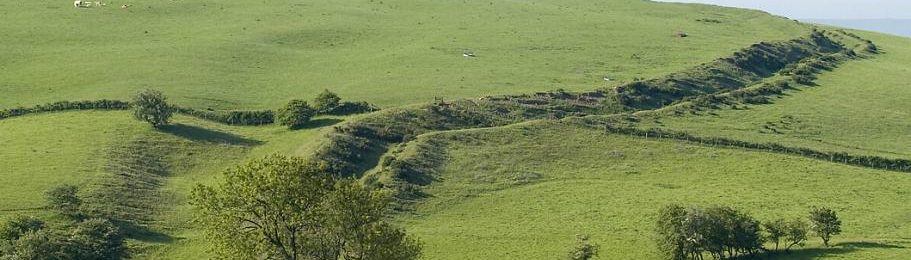
Wat’s Dyke lies a broadly consistent distance of around 3 kilometres to the east of Offa’s Dyke (although that distance narrows to only just over a kilometre in the Dee valley near Ruabon). This close shadowing of one another’s courses suggests a closer relationship existed between them in practical operational terms than has hitherto been thought likely.
- Was Wat’s Dyke built in the same way as Offa’s Dyke?
There are certainly similarities, but there are also important differences – especially in the way that the landscape is traversed. Wat’s dyke crosses a landscape of lower elevation and lesser contrasts in height as between hills and valleys, than Offa’s Dyke does. Meanwhile, there is no suggestion that there was frequent (or indeed any) use of stone in the bank of Wat’s Dyke, and there is at least an impression that it was a slighter structure than Offa’s Dyke. Although it is sited to provide long distance views across the countryside, and it is consistently sited above streams and hill-brows overlooking valleys from the east, it is not so obviously built to dominate eastwards-looking prospects or to provide surveillance westwards in the way that Offa’s Dyke was.
- Are there any theories as to the relationship between the two Dykes?
Traditionally, it has been assumed that the two Dykes were built at different times to one another: either Wat’s Dyke was earlier in date (Cyril Fox ascribed its building to Offa’s immediate predecessor, King Aethelbald). As a result of excavations on Wat’s Dyke at Gobowen and associated scientific dating which suggested a span centring upon the early ninth century, some archaeologists and historians have concluded that Wat’s Dyke was most likely built in the ninth century after Offa’s Dyke was already in place.
One contrasting theory that has been developed in recent years (Keith Ray, 2020: ‘The Discomfort of Frontiers: Public Archaeology and the Politics of Offa’s Dyke’, 117-146 in K. Gleave, H. Williams and P Clarke, eds, Public Archaeologies of Frontiers and Borderlands, Access Archaeology, Archaeopress, Oxford, at pp. 130-2; Keith Ray et al, forthcoming, ‘Offa’s Dyke: a continuing journey of discovery’, Offa’s Dyke Journal 3, 2021) suggests that the two Dykes are actually (or at least broadly) contemporary: probably within the last two decades of the eight century. The idea here is that the Dykes were deliberately planned and built to be used together, both to create a ‘free-trade’ zone between them, and to incorporate the lead mining district of Halkyn Mountain within a zone of overall Mercian control.