
Panel 13: (a) Archaeological fieldwork
The supplementary information provided in this QR-code accessed section takes the form of a series of questions that you may have about how the Dykes have been (and are being) recorded.
- What excavations have taken place on Offa’s and Wat’s Dykes?
Archaeological fieldwork on Offa’s and Wat’s Dykes has involved both survey and excavation. Survey is discussed in the supplementary text (below) that describes the use of a field compass by Sir Cyril Fox for his late 1920s and early 1930s surveys [in section ‘Panel 13 (b)’].
The first recorded ‘modern’ excavation was instigated in 1922 by the colonial anthropologist Northcote Thomas on a location on Baker’s Hill north-west of Oswestry (Thomas came from nearby Trefonen). The ‘excavation’ involved the digging out of a length of the Dyke by members of the (then) newly formed ‘Oswestry Prehistoric Society’. Finding very few artefacts, they soon switched their attention to the investigation of Old Oswestry Iron Age hillfort.
Cyril Fox undertook five excavations along the course of Offa’s Dyke between 1926 and 1929. At only one of these, at Ffrith in Denbighshire, did he retrieve unequivocal evidence of historical and structural importance. Here, he demonstrated that Offa’s Dyke had been built some while after the abandonment of a Romano-British settlement at the same location but contained no medieval pottery or other similar material. It therefore could be ‘bracketed’ in time between AD400 and AD1100: in other words, in the Early Medieval period.
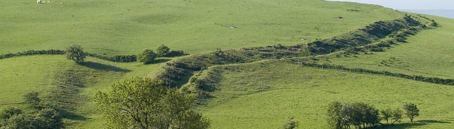
The most informative excavation so far undertaken on the Dyke was undertaken by staff of the Clwyd-Powys Archaeological Trust here in Knighton at Frydd Road in 1976 in response to a road-widening scheme. This provided important evidence about the digging of the ditch and the building (and erosion) of the bank. It has therefore been used as the basis for the ditch and bank elements of the large cross-section across Offa’s Dyke that has been drawn up for this section of the Exhibition.
No excavation has so far taken place that has looked at the full span of either Dyke, taking in (from west to east) the counterscarp bank, the ditch, the bank and the quarry-ditches.
A thirty-year long project by extra-mural staff and students from Manchester University between the mid-1970s and early 2000s was said to have involved over 100 excavations on the line of both Dykes. Unfortunately, limitations on access to well-preserved lengths, a strategy of looking for particular kinds of evidence only (such as presence/absence of the ditch), the opening of trenches that were often too small or poorly sited, lack of provision of resources for scientific analyses (especially dating), and sometimes the making only of peremptory records, meant that little of this work was as informative as it might have been. None of it has been fully published, and no dating evidence has been forthcoming.
In recent years, excavations of Wat’s Dyke at Gobowen near Oswestry and at Erddig near Wrexham, and of Offa’s Dyke at Plas Offa, Chirk and at Chirk Castle Park have produced suites of scientific dates. These dates, derived from complementary dating techniques, provisionally place the building of both Dykes in the crucial late eighth to early ninth century period of the ‘Mercian hegemony’. They have also produced a wealth of new data concerning the methods used to construct both linear earthworks.
- What have we learned from excavations that we cannot know by other means?
One obvious thing that we have learned concerns the depth and character of the ditches of both Dykes. We now know, for example, that the profile of the ditches as dug ideally followed Roman military practice. This involved cutting a narrow slot at the base of the otherwise mostly V-profiled ditch, not only to provide drainage on slopes but also to serve as an ‘ankle-breaker’ for anyone attempting to cross the ditch.
We have learned that while the main purpose of digging the ditch to the west of the bank was to provide material for the counter-scarp bank, the material for the main bank was likely to have come mostly from quarries to its rear.
We have also realised that the bank once had (in most locations) a capping of loose stones. This was not a ‘wall’ as such but was designed to look like one. Because it was not built as a structure, the stones soon slipped down into the ditch. In only a few locations does it still serve as a capping, resisting further erosion.
- What is the impact of new technologies and scientific techniques on our understanding of the date and purpose of the Dykes?
As yet the impact of scientific techniques used in the excavation of the Dykes has been quite limited. However, we are at the beginning of a new era of investigations. For example, new dating techniques such as Optically Stimulated Luminescence (OSL) are being used. This enables an estimate to be made of the last time a soil surface was exposed to sunlight. Used in conjunction with radiocarbon dating of short-lived organic material (bones, carbonised twigs and seeds, etc), this can narrow down the period of construction of a work such as Offa’s Dyke. We also need to excavate and date the Dyke at several locations, to find out whether it was built all at once, or in stages.
- What is there still to do?
The short answer to this question is ‘an enormous amount.’ We need to conduct archaeological excavations not only at badly damaged or entirely levelled places, but also where relatively good preservation will enable us to gain better insights into how the bank (especially) was built and stabilised.
We also need to better test the idea that there were gateways through the Dyke to control movement from west to east and vice-versa. This can only be done by open area excavations at certain among the more promising locations.
Panel 13 (b) Fox’s compass, and surveying the long Dykes
 The supplementary information provided in this QR-code accessed section takes the form of a series of questions that you may have about the surveying compass and how the earthworks have been recorded other than by archaeological excavation.
- What more can be said about the compass?
Fox acquired this field compass following his release from military duties in 1919. He used it extensively for orientation and preliminary surveying work for his work on the linear dykes in Cambridgeshire and for his massive 1925-32 survey of Offa’s Dyke and Wat’s Dyke. It is displayed alongside its initialled leather carrying pouch. The following detail has kindly been supplied by George Fox, Cyril and Aileen Fox’s youngest son, who has also gifted the compass, a treasured family heirloom, to the Offa’s Dyke Association in perpetuity, as a memorial to his father. During 2023 it will be on loan to the Cambridge University Museum of Archaeology and Anthropology for an exhibition commemorating the 100th anniversary of the publication of Cyril Fox’s Archaeology of the Cambridge Region (a book celebrated for its pioneering use of archaeological distribution maps and for the extent of contribution of Fox’s own fieldwork towards its contents). George Fox writes:
“The compass was made in 1918 by a company called Verners which has a patent with a serial number which corresponds to 1918 (so the one he had used in the war as an instructor would have been handed in). The company is named after Colonel Willoughby Verner, 1852-1922 who invented this type of compass. It has the original leather case and as the restorer said it was a quality piece; it has numbers below the rim, 2 buttons and a view finder. (My father) would have used it in his work for Archaeology of the Cambridge Region for there would have been little space on a bicycle for a theodolite or a 6ft pole! The London maker of this compass under licence from the company Verners was Cruchon and Emons of London. Closer examination will show you the arrow for wartime distribution (though Cyril had left the army he bought this compass privately in an up market shop in London).
You will see that it is a heavy piece of equipment, the reason for this is that it would have to be robust in wartime when a soldier could be running or climbing out of the trenches with heavy kit on. It would have been worn by an officer and attached to his ‘Sam Browne’ belt by the strap on the back of the leather case. At this time compasses were being improved and updated or modified as their use changed. One of the useful things of this ‘new’ compass was it had a prism and view finder which raises its status to ‘Prismatic compass’. It means that the users can it for both navigation and as a surveying instrument. Hence the purpose of Cyril purchasing this new compass for his projected work on Archaeology of the Cambridge region and would be very useful to him during his five years survey of Offa’s Dyke.”
- How did Cyril Fox organise his survey?
Sir Cyril Fox gave a detailed description of how he conducted his survey at several points in his 1955 book and in his annual published reports for the Cambrian Archaeological Association brought together for that book.
- What studies did Frank Noble make that changed our view of the Dyke?
Frank Noble carried out no detailed recording surveys of either Offa’s Dyke or Wat’s dyke. What he did do was to make a close study of all relevant documents and much local Welsh documentary evidence from the Middle Ages. His other contribution was close field studies of especially the southern lengths of the Dyke in Gloucestershire (where he felt that Fox’s field studies were too hastily conducted to be sufficiently accurate), and in Radnorshire and south Shropshire. It was therefore those chapters of Frank’s Masters thesis at Birmingham University that his thesis supervisor, Dr. Margaret Gelling, thought were most worthy of publication following Frank’s premature death in 1980 (F. Noble ed M. Gelling, 1983, Offa’s Dyke Reviewed, British Archaeological Reports 113.
- Has there been any very detailed recording of the Dyke since Fox?
Extraordinarily, only one length of Offa’s Dyke has ever been recorded through very detailed earthwork survey. However, in recent years, various methods of remote sensing either as flown from aircraft at some height, or using drones, has opened up the possibility of making minutely-detailed records of the form of the dyke at different locations.