
The supplementary information provided in this QR-code accessed section takes the form of a series of questions that you may have about the ‘What and Why?’ section of the exhibition. For more information about the building of the Dyke, you can access the website of the Offa’s Dyke Collaboratory (www.offaswatsdyke.wordpress.com); and you can also access there, on an open access basis, all the articles published in the volumes of the Offa’s Dyke Journal. The ODJ is a periodical (annual) publication that carries peer-reviewed articles not only on the Early Medieval frontier between England and Wales, but also papers that discuss the history and archaeology of historic boundaries elsewhere in Britain, Ireland, continental Europe and beyond.
You can also read in some depth about the Dyke and the historical context of its construction in the book Offa’s Dyke: Landscape and Hegemony in Eighth-Century Britain by Keith Ray and Ian Bapty (Windgather Press, 2016; reprinted 2019). A new book by Keith Ray, Offa’s Dyke: Encounters and Explanations, which will serve not only as an introduction to current thinking but also as a detailed field guide to the monument, will be available during 2022.
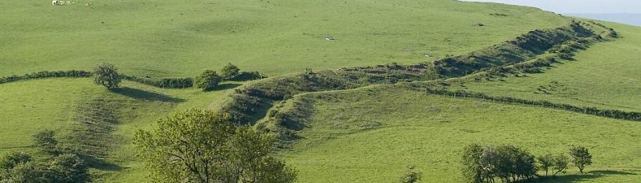
Panels 4 and 5 Offa’s Dyke: built to control and impress
- What do we currently know about the true extent of Offa’s Dyke?
Over the years, opinions have differed about not only the nature and purpose of the Dyke, but also about its date and very extent. In Cyril Fox’s time, it was thought that it extended from Sedbury near Chepstow on the Bristol Channel all the way north to the Irish sea at Prestatyn, with gaps in parts of Gloucestershire, much of Herefordshire, along the Severn east of Welshpool, and in parts of Flintshire.
Then around the year 2000, it was proposed by Dr David Hill that the ‘real’ Dyke only extended from Rushock Hill in north-west Herefordshire to Treuddyn in Flintshire: although no satisfactory explanation was given for the existence of typical Dyke lengths in Gloucestershire or west Herefordshire, or for its absence across most of Flintshire.
By 2016, the contrary view (as articulated by Keith Ray and Ian Bapty, in Offa’s Dyke: Landscape and Hegemony in Eighth-Century Britain) had formed that the known Gloucestershire and Herefordshire lengths were integral parts of the original scheme, but that the Dyke had terminated (for whatever unknown reason) at Treuddyn, where the last ‘convincing’ length was known.
Between 2017 and 2019, new reconnaissance on foot by Keith Ray in collaboration with others has demonstrated the likelihood that the Dyke was originally continuous (and can mostly be traced) from Sedbury at least as far as Lower Lydbrook in Gloucestershire, and quite probably north from there at least to the environs of Ross-on-Wye.
Meanwhile in Flintshire, Ray Bailey, Keith Ray and other colleagues have traced lengths of bank very similar to the Dyke elsewhere (and to Wat’s Dyke in Flintshire), near Mold and Caerwys, and down the steep hill towards the sea between Gronant and Prestatyn. This raises the possibility that the Dyke did indeed stretch ‘from sea to sea’ as stated by Bishop Asser in the late ninth century AD.
And since 2019, LiDAR studies and groundwork in north Herefordshire by Liam Delaney have confirmed the continuity of the Dyke from the Wye at Bridge Sollers to Rushock Hill, despite near-obliteration in some locations by road building, landscaping and agricultural operations.
- What were the main principles behind the siting of the Dyke in the landscape?
At the largest scale, the concern appears to have been to take as direct route as feasible from sea to sea, keeping to a north-south orientation. The line chosen was mostly just into the true uplands and ensuring the appropriation of all extensive lowlands to its east with high agricultural potential.
Some slightly more localised shifts were deemed necessary, following north-north east to south-west orientations, or north-north-west to south-east ones. A major displacement occurred south-eastwards towards the southern end, to take the Dyke down the eastern side of the lower Wye valley.
Much more locally, adjustments were often made on some hilltops to take the course around the crest of west-facing slopes; and at river valley traverses, to ensure that the approaches to the Dyke (and likely crossing-points) were overlooked from north and south.
In such locations, the aim was twofold: to make the Dyke appear more prominent in the landscape when seen from the west, and to take advantage of opportunities for surveillance from and along the Dyke.
(See Ray and Bapty, 2016, noted above, for details of routing and placement in the landscape).
- What did the building of Offa’s Dyke achieve?
In the short-term, perhaps in the first thirty or so years after its construction, the Dyke enabled the creation of a much more clearly defined frontier zone than had previously been achieved. This zone would have comprised a ‘forward’, a ‘central’ and a ‘rear’ component. All three were zones of surveillance and control. The first of these was a landscape within which Anglo-Saxon settlement or influence was occurring. The central zone comprised the Dyke and would in some locations probably have been militarised. The rearward zone would have been a landscape in which communications would have been most important, with movement facilitated both north and south (in some places using former Roman roads) and east and west (the saltways and droving routes that had long existed).
In the longer term what building the Dyke achieved was twofold. Firstly, it sealed Offa’s personal reputation as a plenipotentiary (and widely feared) figure and served to perpetuate his memory even into modern times. Secondly, it facilitated both a stronger definition of the existence of, and the limits to, the territorial expression of English settlement and Welsh identity. That this has had a historical impact on the population composition of the two political and cultural entities (Wales and England) has become clear from contemporary DNA studies of present-day (or near-present-day) residents. These show a clear heritance threshold east and west of the (broad) Mercian frontier zone in the fundamental genetic composition of the respective populations.
- How long-lasting was its use and how permanent were its effects?
As a fundamentally military work, the use of the Dyke was probably relatively short-lived, because of the impact of the Danish/Viking incursions from the ninth century onwards, and also of the consequences of the rise of the Kingdom of Wessex among the Anglo-Saxons as a consequence of both its military resurgence and then its capacity to survive the trauma of Danish/Viking armies and then settlement.
Arguably, the existence of the Dyke also enabled events representing a rapprochement of Anglo-Saxon and Welsh leaders to occur when faced with a common enemy. The pre-eminent example as regards the ‘Dyke-frontier’ here, was the battle at Buttington on the Severn by Welshpool in AD894 at which a combined British (Welsh) and Anglo-Saxon (primarily from Gloucester and Hereford) force routed a Viking army, having trapped them in a fort close to the line of the Dyke.
The effects of the building of Offa’s Dyke were nonetheless permanent in the terms expressed in the previous question. The survival in both semi-independence and full independence of the Welsh kingdoms and polities from the ninth century onwards ensured the survival of a rich cultural tradition and literature, without which neither the phenomenon of Tudor political dominance nor the revival of language and politics from the industrial revolution onwards would have been possible.