
The supplementary information provided in these two QR-code accessed sections takes the form of a series of questions that you may have about the ‘Offa’s Dyke Path’ national trail described in this part of the exhibition.
Panels 8, 9 and 10 Introducing the Offa’s Dyke Path National Trail
- How long does it take to walk the Offa’s Dyke Path?
This of course depends upon how rapidly you walk! And it depends also, upon the time available and what you want to achieve. The most recent Guide (Mike Dunn/ Cicerone, 2016 – see below) indicates that with a strenuous pace averaging around 22 miles/35 kilometres per day the 179 miles/288 km total length of the Path can be walked in 8 days. At a slower average of 12 miles (19km) each day, the same distance can be covered instead in 16 days.
It is of course possible to walk the Path in either direction: starting from Prestatyn by the Irish Sea and heading southwards along the Clwydian Hills or starting from Sedbury cliffs above the Severn Estuary south-east of Chepstow and heading north along the eastern heights overlooking the Wye Valley.
Most walkers prefer the south-to-north direction because the landscape is lit by the sun from behind (so to say) as you walk northwards, affording better views of the landscape opening up before you as you walk.
The best-known guidebooks to the Path are the two-volume National Trail Guides (Offa’s Dyke Path South and Offa’s Dyke Path North) written by Ernie and Kathy Kay. These were first published in 1989 and were revised by Mark Richards in 2007 and 2008 respectively (with photographs by Archie Miles), when they were re-published by Aurum Press.
The most recent ODP Guide is the more compact Cicerone book, Walking Offa’s Dyke Path: National Trail following the English-Welsh Border. Written by Mike Dunn, this compact walking companion includes a separate detailed route map booklet that is based upon the Ordnance Survey 1:25,000 (two and a half inches to the mile) mapping and that can be carried separately for ease of route-following.
The most helpful Guide to the ODP that also provided detailed observations about the Dyke was the long out of print A guide to the Offa’s Dyke Path by Christopher John Wright, published by Constable in 1975 (362 pages long but of compact format, though not especialy easy to use due to its small print size).
It is important to point out, however, that only around half of the distance covered by the Path follows the Dyke closely. This is mostly due to the deliberate choice to add in the breath-taking scenery of the eastern scarp of the Black Mountains in the south and the heather-clad heights of the Clywydian Range in the far north; and to avoid following the Dyke through industrial landscapes in the north, or where the existence and siting of the Dyke is less well-known (or as yet uncertain), for example in Herefordshire and much of Flintshire. For those interested in tracing the original course, or in the archaeology of the monument itself, the soon to be produced Encounters and Explanations book will hopefully provide a useful guide.
It should be mentioned that a trail guide entitled Wat’s Dyke Way Heritage Trail also exists (Pete Lewis, Alyn Books, 2008). The WDWHT is an informal path and route, supported by Wrexham Borough Council locally and using public footpaths and public roads, but is not formally adopted nationally.
- Is the walking very difficult?
What is especially tiring is where the Offa’s Dyke Path involves a lot of clambering up, and down, steep slopes. The Cicerone guide already mentioned helpfully provides height information on its Overview Map. This indicates, for example, that from Pandy to the southern tip of Hatterall Ridge north-east of Abergavenny, the ascent from the south involves a climb of nearly 400m in the space of only around 4km, with an equally abrupt climb when walking south, from Bodfari onto the Clwydians across a similar distance.
Perhaps not surprisingly, the stretch of the Path that involves the most movement up and down steep slopes is that from Kington north to Brompton Bridge.
Ground conditions can vary both from place to place and seasonally, but there are lots of boggy locations featuring heavy and sometimes deep mud, and there are lengths that are rocky and uneven. Wet (and cold) conditions in winter and overgrown vegetation in summer can also inhibit progress!
- Where can you stay along the way?
The ODA and the Path Officer can provide lists of accommodation, as can local authority and tourism websites. Accommodation ranges from hotels and guesthouses to campsites and hostels, most of which are readily reached from the Path, provided you have done the necessary forward planning.
Accommodation in Wales can be sourced through two websites for ‘Visit Wales’ (www.visitwales.com) and ‘Visit Mid Wales’ (www.visitmidwales.co.uk). However, the most comprehensive information with names and addresses for hotels, guesthouses and campsites is available via the Offa’s Dyke Association website itself (offasdyke.org.uk/where-to-stay/accommodation-on-offas-dyke), where there is an annually updated list of accommodation organised by sector of the national trail. This listing is accessible either via the simple list or by a key map showing locations and tabs with contact details. A ‘where to stay’ booklet is also available.
- What are the most scenic sections, and can they be walked in a day?
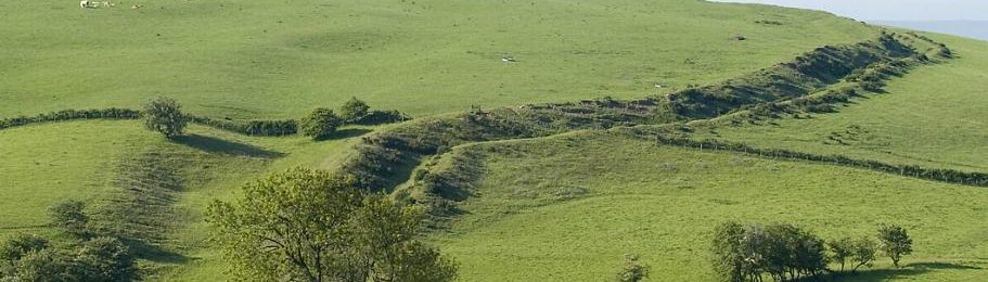
This is of course a subjective matter, and one of personal preference. The most open landscapes with the widest views are along the hilltops already mentioned, while some of the most easily viewable lengths of the Dyke, largely free from obscuring vegetation, are located on LlanfairHill in south Shropshire. Some views are so striking as to imprint themselves upon one’s memory long after the walk has been concluded. Again, apart from the locations already mentioned, the views east to the Cheshire Plain from the Dyke north-west of Oswestry are less well known but are nonetheless remarkable. Meanwhile, the views north from the Kerry Ridgeway across the Vale of Montgomery and beyond to the middle Severn valley and the Berwyn Mountains are vivid on a clear day; and those southwest and west to the Radnor Forest upland from various points north and south of Knighton are also very striking.